Lot 86


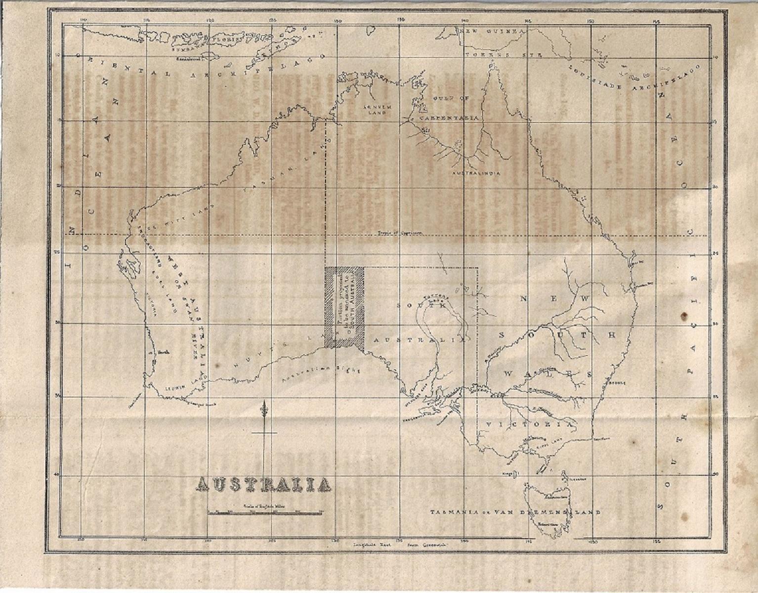
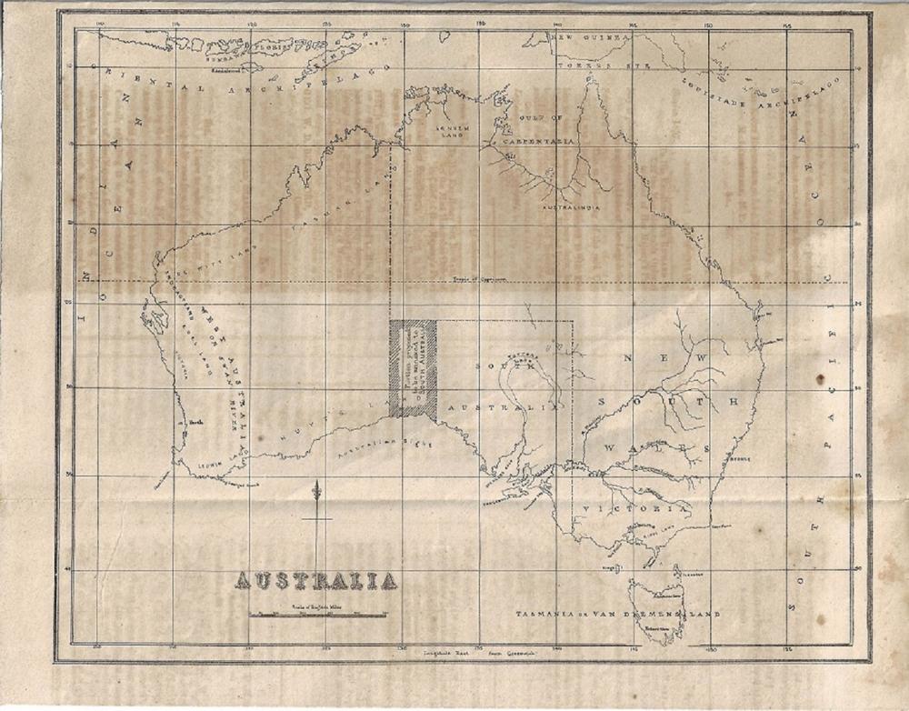
Original copy of the Report to the Legislative Assembly of New South Wales dated 1 October, 1858
-
Provenance:
- Books, Maps & Manuscripts Exhibited:
- Collectibles Literature:
- 2419 Medium:
- Manuscripts Notes:
- In 1856, South Australia became a self-governing colony introducing at the time one of the most democratic constitutions in the civilised world. All men of the new Colony, including indigenous men, could cast a single vote regardless of their circumstances, and secret balloting ensured that their vote was not coerced. Propertied women were granted the right to vote in 1861 but it would take until 1894 before all women could participate in the democratic process. By 1857, the new Colony was pushing its boundaries and, so when it was pointed out that an isolated section of the Australian Continent, that was technically still part of the Colony of New South Wales, would be better serviced by South Australia, a campaign for annexure began. Surprisingly, the area was not on its eastern border which already abutted New South Wales but was a forlorn tract of land on its western boundary between itself and Western Australia. In 1788, at the time of settlement, the western boundary for the Colony of New South Wales was set at 135 degrees east of Greenwich to appease the Dutch whose countryman Abel Tasman had in 1644 labelled the lands beyond 'New Holland.' In 1825, in less diplomatic times, the border was nudged west to 129 degrees to capture a new offshore settlement at Melville Island to the north of the Australian continent and, when Western Australia was settled in 1829 this new border was chosen as the natural divide that would separate the two colonies. Often political decisions are made expediently with little thought of the consequences, as occurred when the Colony of South Australia was decreed by an act of the British parliament in 1834. The surveyed stretch of coastline found in the historical maps of Matthew Flinders, the first explorer to circumnavigate the continent, were relied upon to set its eastern boundary at 141 degrees and its western boundary at 132 degrees. Sailing eastwards Flinders finished his detailed survey of the South Australian coast at the 141 degree meridian which he was no doubt aware was the antimeridian of the Tordesillas Line set in 1494 'when the earth was flat' that split the unknown world between the Spanish and the Portuguese. The reason for choosing the 132 degree meridian for the western border is less clear but, coincidently it does coincide with the beginning and the end of two of Flinders charts. On his Chart finishing at the 132 degree meridian Flinders credits another Dutchman Peter Nuyts with the discovery of that part of the South Australian Coast in 1627, while himself claiming discovery rights for anything further east. Did the decision-makers in London take note of Flinders' courteous acknowledgement or, was the border decided by a pen-pusher who couldn't be bothered to turn the page? Whatever the true reason, the decision left a gap of three degrees longitude between South Australia and Western Australia, an area which still legally belonged to New South Wales. The squatters were already moving on to this ungoverned land which was separated from its home state by the Colony of South Australia, and so on 1st October 1858 the Legislative Assembly of New South Wales tabled a proposal complete with map of the area South Australia sought to secure. Of course, New South Wales could have carried on with the territories of 'East' New South Wales and 'West' New South Wales but, in the end common sense prevailed and in 1860 the land was finally absorbed into South Australia and the 129 degree border with Western Australia recognised. This was probably a wise move, as a similar circumstance didn't quite work out 100 years later when the partitioning of British India created the separated regions of 'East' and 'West' Pakistan which eventually led to a bloody civil war for independence.
Accepted Forms of Payment:
American Express, MasterCard, Money Order / Cashiers Check, Paypal, Visa, Wire Transfer
Shipping
AUSTRALIA: Purchases within Australia will be charged a MINIMUM SHIPPING FEE of $5.50 and will be sent by Registered Post. Additional insurance is optional at the buyer's expense.
INTERNATIONAL: Overseas purchases will be charged a MINIMUM SHIPPING FEE of $20.00 and will be sent by Registered Post International. Additional insurance is optional at the buyer's expense.
Both Australian and International packages are traceable in transit and require a signature on delivery.
Smalls Auctions
You agree to pay a buyer's premium of up to 20% and any applicable taxes and shipping.
View full terms and conditions
| From: | To: | Increments: |
|---|---|---|
| A$0 | A$249 | A$5 |
| A$250 | A$999 | A$10 |
| A$1,000 | A$4,999 | A$25 |
| A$5,000 | A$9,999 | A$50 |
| A$10,000 + | A$100 |


